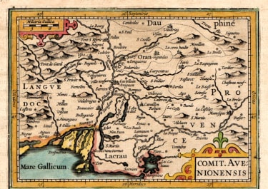
COMIT. AVENIONENSIS
£95
Attractive and detailed map by Petrus Bertius of Southern France, showing the Rhône river and the Camargue. Including Arles, Avignon, Orange Aix etc.
This Bertius / Hondius map originally engraved in 1616 was used in Merula's Atlas in 1621. Set in a page of descriptive text.
Very good hand colour
Very good condition
From: Merula P. Cosmographia generalis Libri tres, ... Amsterdam, 1621.
code : M5321
Cartographer : Petrus BERTIUS
Date : 1616/+ Amsterdam
Size : 10*13.5 cms
availability : Available
Price : £95
Petrus BERTIUS
The origins of the miniature pocket atlas lie in Barent Langenes Caert Thresoor of 1598. A large number of the 169 maps were engraved by Petrus Kaerius (Van Den Keere). This small but attractive atlas was sold for the first time in 1599 by Cornelis Claesz in Amsterdam. In 1600, Claesz published the atlas with a Latin text composed by Petrus Bertius; from then on, new editions, often enlarged with new maps, regularly appeared. Petrus Bertius was born at Beveren, Flanders, in November 1565. As a refugee, Bertius settled in Amsterdam and, after finishing his studies, he became a professor of mathematics and librarian at the University of Leiden. In 1618 he also became cosmographer and historiographer to Louis XIII of France, and lived in Paris, where he died in October 1629. His fame among geographers was established by his text in the pocket atlas Tabularum Geographicarum.