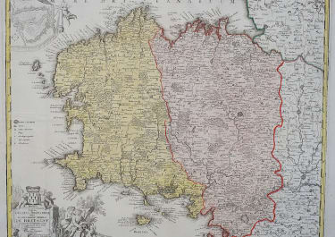
PROVINCIA INDIGENIS DICTA LA PROVENCE
£345
A beautiful and highly detailed map of Provence in southern France that covers the region from Arles to Monaco. It provides a great deal of information with place names, castles, monasteries, rivers, lakes, woods, mountains and fortifications prominently engraved. Locates Nice, St. Tropez, and much more. The map features an inset map of the Battle of Toulon of 1707 during the War of the Spanish Succession. The extravagant title cartouche shows noblemen emptying their coffers to Marshall General Villars in support of the war.
Very crisp impression with strong, original full color.
Good condition;
code : M3301
Cartographer : Homann
Date : 1715c Nuremberg
Size : 49*58 cms
availability : Available
Price : £345
The Family HOMANN
Johann Baptist Homann (1664-1724) started his career in Amsterdam as an apprentice with the Danckerts family before returning to Nuremberg to establish himself in business in 1702. The firm quickly became the principal geographical publishers in Germany and in 1715 Homann was appointed Geographer to the Holy Roman Emperor and he was also a member of the Prussian Royal Academy of Sciences. His publications included the “Neuer Atlas Ueber Die Gantze Welt ...” in 1707-. The “Grosser Atlas ...” of 1716- and the “Atlas Novus Terrarum Orbis Imperioa” in c.1720, as well as many others. Johann died in 1724 and was succeeded by his son Johann Christoph who died in 1730. After his death the firm took the name Homann’s Heirs and continued thereafter until 1813. Publications with the Homann’s Heirs’ imprint included the “Grosser Atlas” in 1731, Doppelmays’r “Atlas Coelestis ...” in 1742 and the “Atlas Geographicus Maior ...” in 1753-, amongst others. Throughout this entire period the firm were the leading map publishers in Germany, employing a number of very important cartographers