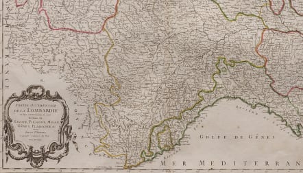


PARTIE OCCIDENTALE DE LA LOMBARDIE
£195
Title: 'Partie Occidentale de la Lombardie et pays circonvoisins, où sont les Etats de Savoye, Piémont, Milan, Gênes, Plaisance &c. Par le Sr. Robert, Géographe ordinaire du Roy. Avec Privilege'
Attractive and detailed map covering the area of the western part of Lombardy, Italy including Savoy, Piedmont, Milan, Genoa, Plaisance, Nice, Turino, St. Moritz, Geneva, Grenoble, and Lake Como. Shows rivers mountains towns and villages.
Decorative cartouche.
Original outline colour
Very good condition
code : M4904
Cartographer : VAUGONDY ROBERT DE Family
Date : 1757 Paris
Size : 48.5*56 cms
availability : Available
Price : £195
The Robert de Vaugondy family responsible for map and globe publishing in Paris comprised Gilles Robert de Vaugondy (1688-1766) and Didier Robert de Vaugondy (1723-1786). The father (Gilles) and son (Didier) business flourished from 1731 to 1778.
Prominent at this time among French map-makers were the Robert de Vaugondy family, who made a substantial contribution to the eighteenth century world of cartography, through the breadth and success of their prolific output, which included atlases, maps, globes and book illustration.
While only a small part of their output, the "Atlas Universel" encapsulates the diligent and scientific approach adopted by the Roberts de Vaugondy, and proved to be the most successful French world atlas of the period. It appeared from c.1757 onwards.