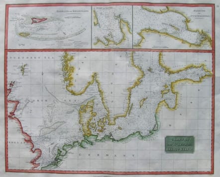
BALTIC SEA CHART OF THE NORTH AND BALTIC SEAS
Sold
A beautiful map of the North and Baltic seas, published in Thomson's New General Atlas. One of the sea charts to have appeared in Thomson's Atlas. Includes excellent coastal detail, soundings, etc. Shows and names many reefs and banks. Insets of the Harbour of Heligoland, the Port of Revel, and the Harbour of St. Petersburg are again in excellent detail, with soundings and other fine details. This spectacular map is printed on heavy paper and has ample margins.Good hand colour.Very good condition.
code : M2509
Cartographer : John Thomson
Date : 1815 c Edinburgh
Size : 48.5*60cms
availability : Sold
Price : Sold
THOMSON, John
flourised 1814-1869
John Thomson produced two major works in his life time, A New General atlas of the World 1814-28 and Atlas of Scotland 1820-32. The maps from A New General atlas of the World were printed in full hand coloring from large copperplate engravings. The level of detail at the time of publication was heralded as a breakthrough in British cartography and Thomson rightly earned a great deal of attention and his work copied for a number of years