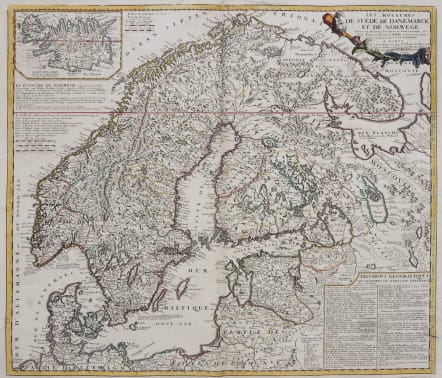


SCANDINAVIA LES ROYAUMES DE SUEDE DE DANEMARCK ET DE NORWEGE
£385
Good attractive map of Scaninavia .
Scarce map of Scandinavia and the Baltic with inset map of Iceland. Published by Jean Baptiste Nolin, the Geographer to the King of France. With text panels giving geographical divisions of the region. The map is prepared by Jean Nicolas, Sieur de Tillemont after sources as Andreas Bureus (1571-1646) and J. Scheffer.
This is the second issue of this map printed in 1742.
Original outline coloure.
Printed on heavy paper. Strong impression.
Very good condition
code : M5059
Cartographer : NOLIN Jean Baptiste
Date : 1691 / 1742 Paris
Size : 48.5*56.5 cms
availability : Available
Price : £385
NOLIN, Jean Baptiste
c. 1657-1708
J. B. Nolin set up the family publishing business in Paris in the Rue St Jacques where he engraved and sold a wide variety of maps, on some of which he wrongfully used the titles 'Engraver to the King' and 'Geographer to the Duke of Orleans'. On a complaint by Guillaume Delisle he was accused and convicted of plagiarism but his business continued to flourish.
Many of his maps were based on the work of Vincenzo Coronelli, the Italian cartographer and of another French geographer, Sieur de Tillemon (Nicholas de Tralage). His most notable work was the publication in 1696 of a World Map on one sheet based on J. D. Cassini's 24-ft planisphere housed in the Paris Observatory.
His son JEAN BAPTISTE NOLIN (1686-1762), continued the business for many years and prepared an Atlas General which was published posthumously in 1783.