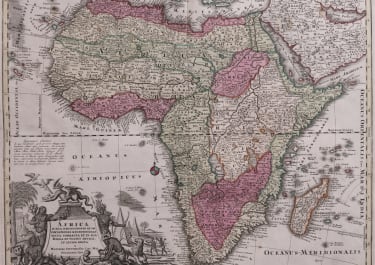
AFRICA LUXTA NAVIGATIONES
£585
Attractive bold map of Africa is based largely on Homanns 1715 map.
Typical of the period, it presents largely fictitious information in southern Africa, and enormous lakes depicted in central Africa. The Nile is shown originating in the south at lakes Zaire and Zaflan and also continuing further south through a twisted river system with its headwaters in Bed Lac. The splendid decorative cartouche features indigenous people, pyramids and exotic animals, with a fierce dragon perched atop the title.
Good strong original colour
Cartouche uncoloured as always wuth Seutter maps.
Very good condition
code : M4364
Cartographer : SEUTTER Family
Date : 1730 Augsberg
Size : 51*58.5 cms
availability : Available
Price : £585
Besides the Homanns, the other great German publishers of the eighteenth century were the Seutter family. Mattheus Seutter the elder (1678-1757) was apprenticed to Johann Baptist Homann in 1697 in Nuremberg, but left to settle in Augsburg where he established his own business publishing atlases, including the "Atlas Geographicus" (1725) and "Grosser Atlas" (circa 1735). Seutter's style was heavily influenced by Homann, with distinctive similarities appearing in his maps. He was joined in the business by his son, Albrecht (1722-1762), who continued the firm in partnership with Tobias Conrad Lotter (1717-1777) on his father's death.