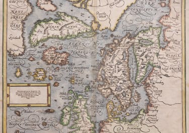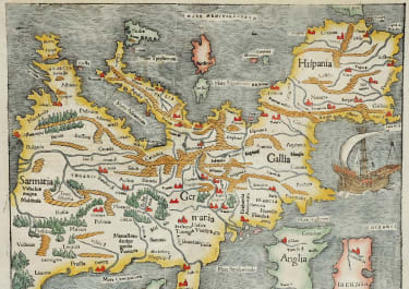


DESCRIPTION NOUVELLE D'EUROPE
£1250
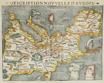
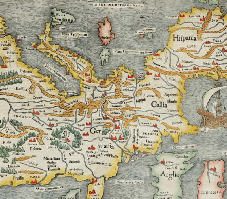
Striking, Inverted Europe Map.
One of the earliest acquirable, separate maps of Europe. This intriguing depiction of Europe oriented with south at the top was unusual even for its early period. Though unusual and even quaint to the modern eye, the map’s orientation was neither an error nor a regression, but in fact an indication of its modernity. Maps based on Ptolemaic sources shared the second-century geographer’s northern orientation. However, regional maps printed in Germany in the first part of the 16th century for the use of travelers were oriented to the south in order to be used in conjunction with a solar compass. Since these represented Munster’s most accurate and detailed modern sources, his maps derived from them virtually all shared the same orientation.
Most important among Munster’s sources was Martin Waldseemuller’s 1511 Carta itineraria europae, a four-sheet wall map of Europe, which in turn was heavily influenced by the 1500 and 1501 traveler’s maps of Erhard Etzlaub. While Waldseemuller’s grand work includes considerably more detail than Munster’s much smaller map, its influence both in terms of scope and orientation is unmistakable. The 1511 Carta itineraria europae has survived in a single copy of its 1520 edition; the only other derivative of the map is Munster’s extremely rare 1536 Tabula Europa, which was the precursor to his Moderna Europae Descriptio.
Excellent hand colour
Very good condition.
code : M5165
Cartographer : Sebastian Munster
Date : 1550 Basel
Size : 27*34.5 cms inc title sheet 32*41 cms
availability : Available
Price : £1250
Originally a scholar studying Hebrew, Greek and mathematics, Sebastian Munster (1489-1552) eventually specialised in mathematical geography and cartography. It was this double ability - as a classicist and mathematician - that was to prove invaluable when Munster set himself to preparing new editions of Solinus’ “Memorabilia” and Mela’s “De Situ Orbis”, two classical descriptive geographies containing maps, and his own two greatest works, the “Geographia” and “Cosmographia”. These reflect the widespread interest in classical texts, which were being rediscovered in the fifteenth century, and being disseminated in the later fifteenth and sixteenth century, through the new medium of printing.
The “Geographia” was a translation of Ptolemy’s landmark geographical text, compiled in about 150 AD., illustrated with maps based on Ptolemy’s calculations, but also, in recognition of the increased geographical awareness, contains a section of modern maps. In the first edition of the “Geographia”, Munster included 27 ancient Ptolemaic maps and 21 modern maps, printed from woodblocks. Subsequent editions of the “Cosmographia” were to contain a vast number of maps and plans.
One consequence of Munster’s work was the impetus it gave to regional mapping of Germany, but Munster was also the first cartographer to produce a set of maps of the four continents on separate maps. Most importantly, through his books (the “Geographia” and “Cosmographia” alone ran to over forty editions in six languages), Munster was responsible for diffusing the most up-to-date geographical information throughout Europe.