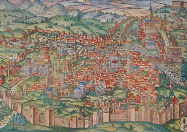
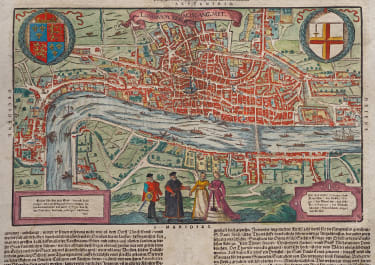
LONDON ODER LUNDEN DIE HAUPESTATT IN ENGELLANDE
Sold
RESERVED
Superb example of this the only 3rd map of London. Based on Braun & Hogenbergs's map.
Double page woodblock map of the Elizabethan city of London showing the area between Clerkenwell, Wapping, Southwark and Westminster Abbey. Two magnificent coats of arms, two columns of text within map referring to the City gates ( and two columns of text below map).
Several vessels in the Thames. Two gentlemen with their elegantly dressed ladies in the foreground. Excellent full color example of this highly sought after plan of London.
Exceptionally good condition with no repairs..good margins .. etc.
References: Howgego #6.
Now a v. rare map
code : M4138
Cartographer : Sebastian Munster
Date : 1598 /+ Basel
Size : 31*38cms Set in page of35*41cms
availability : Sold
Price : Sold
Originally a scholar studying Hebrew, Greek and mathematics, Sebastian Munster (1489-1552) eventually specialised in mathematical geography and cartography. It was this double ability - as a classicist and mathematician - that was to prove invaluable when Munster set himself to preparing new editions of Solinus’ “Memorabilia” and Mela’s “De Situ Orbis”, two classical descriptive geographies containing maps, and his own two greatest works, the “Geographia” and “Cosmographia”. These reflect the widespread interest in classical texts, which were being rediscovered in the fifteenth century, and being disseminated in the later fifteenth and sixteenth century, through the new medium of printing.
The “Geographia” was a translation of Ptolemy’s landmark geographical text, compiled in about 150 AD., illustrated with maps based on Ptolemy’s calculations, but also, in recognition of the increased geographical awareness, contains a section of modern maps. In the first edition of the “Geographia”, Munster included 27 ancient Ptolemaic maps and 21 modern maps, printed from woodblocks. Subsequent editions of the “Cosmographia” were to contain a vast number of maps and plans.
One consequence of Munster’s work was the impetus it gave to regional mapping of Germany, but Munster was also the first cartographer to produce a set of maps of the four continents on separate maps. Most importantly, through his books (the “Geographia” and “Cosmographia” alone ran to over forty editions in six languages), Munster was responsible for diffusing the most up-to-date geographical information throughout Europe.