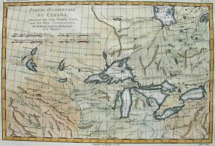
THE GREAT LAKES PARTIE OCCIDENTALE DU CANADA
Sold
An excellent late 18th Century map of the Great Lakes and upper Mississippi River Basin, extending to the Lake of the Woods.
The map provides an excellent overview of the river systems in the Midwest and sources of the Mississippi, including early French forts, Indian names and settlements and other geographic details. From one of the most famous and important works on the East and West Indies of the 18th Century.
Printed on heavy paper.Excellent hand colouring.Mint condition,.
code : M2143
Cartographer : BONNE Rigobert
Date : 1780c Paris
Size : 22*32.5cms
availability : Sold
Price : Sold
Rigobert Bonne (1727-1795), a prolific French cartographer, was active between about 1760 and 1788, working in the French Hydrographical Office, and appointed as Hydrographer to the French King.
Bonne prepared a large number of charts, some of which appeared in the Atlas Maritime. Today, he is best known for the smaller maps that he prepared for Raynal’s Atlas de Toutes Les Parties Connues du Globe Terrestre, published in 1780, and the Atlas Encyclopedique, published in conjunction with Nicholas Desmarest. Although the maps are relatively plain, dispensing with the decorative embellishment of mid-century, they are detailed and provide good coverage of newly discovered regions.