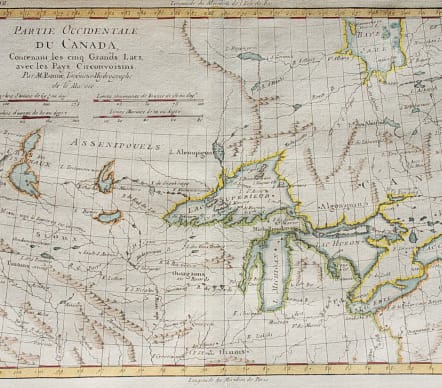

PARTIE OCCIDENTALE DU CANADA CONTENANT LES CINQ GRANDS LACS
£225
An attractive and one of the most interesting maps of the Great Lakes that depicts frontier forts, missions, and fur trade routes. It covers the region from James Bay to just below Ft. Duquesne and from Lake Ontario through the Great Plains. It contains numerous Indian tribe names and forts including Detroit, St. Louis, Toronto and Chicagou. Lake Superior contains Isle Royale, as well as the phantom islands of St. Anne, Maurepas and Ponchartrain, which were reported by the Jesuit explorer Charlevoix. The Keweenaw Peninsula is noted as Pt. de Kiaonan. The source of the Mississippi is noted as inconnu or unknown. First state, engraved by Andre.
Very good hand colour
Excellent condition
Kershaw, Early Printed Maps Of Canada III, 975
code : M3842
Cartographer : BONNE Rigobert
Date : 1775 Paris
Size : 21*31.5 cms
availability : Available
Price : £225
Rigobert Bonne (1727-1795), a prolific French cartographer, was active between about 1760 and 1788, working in the French Hydrographical Office, and appointed as Hydrographer to the French King.
Bonne prepared a large number of charts, some of which appeared in the Atlas Maritime. Today, he is best known for the smaller maps that he prepared for Raynal’s Atlas de Toutes Les Parties Connues du Globe Terrestre, published in 1780, and the Atlas Encyclopedique, published in conjunction with Nicholas Desmarest. Although the maps are relatively plain, dispensing with the decorative embellishment of mid-century, they are detailed and provide good coverage of newly discovered regions.