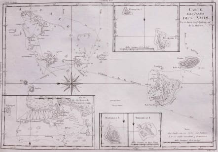
CARTE DES ISLES DES AMIS
£65
Interesting and deatailed map. With four maps on one sheet,, the main one shows the islands of Tonga, orientated with north to the left, with insets of 'Plan du Havre de Tongataboo' and the islands of Mangeea, Tooboui and Wateeoo. Shows the tracks of the Resolution and the Discovery.
Very good condition.
code : M3151
Cartographer : BONNE Rigobert
Date : 1780 Paris
Size : 23*35 cms
availability : Available
Price : £65
Rigobert Bonne (1727-1795), a prolific French cartographer, was active between about 1760 and 1788, working in the French Hydrographical Office, and appointed as Hydrographer to the French King.
Bonne prepared a large number of charts, some of which appeared in the Atlas Maritime. Today, he is best known for the smaller maps that he prepared for Raynal’s Atlas de Toutes Les Parties Connues du Globe Terrestre, published in 1780, and the Atlas Encyclopedique, published in conjunction with Nicholas Desmarest. Although the maps are relatively plain, dispensing with the decorative embellishment of mid-century, they are detailed and provide good coverage of newly discovered regions.