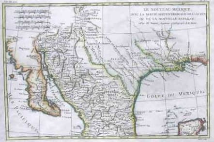
(MEXICO CALIFORNIA TEXAS)LE NOUVEAU MEXIQUE NOUVELLE SPAIN
£175
This attractive map of the southern part of North America shows as far north as Santa Fe and to just below Guadalahara, also including the northern tip of the Yucatan Peninsula. The southern coast of the United States in included to western Florida, and the river systems are included inland, especially for present-day Texas.Hand colour.Heavy paper,mint condition.
code : M624
Cartographer : BONNE Rigobert
Date : 1780 Paris
Size : 21*32cms
availability : Available
Price : £175
Rigobert Bonne (1727-1795), a prolific French cartographer, was active between about 1760 and 1788, working in the French Hydrographical Office, and appointed as Hydrographer to the French King.
Bonne prepared a large number of charts, some of which appeared in the Atlas Maritime. Today, he is best known for the smaller maps that he prepared for Raynal’s Atlas de Toutes Les Parties Connues du Globe Terrestre, published in 1780, and the Atlas Encyclopedique, published in conjunction with Nicholas Desmarest. Although the maps are relatively plain, dispensing with the decorative embellishment of mid-century, they are detailed and provide good coverage of newly discovered regions.