
LE MONDE DE NOUVEAU..LES TABLES DES ISLES NEUFUES..
Sold
RARE ..First map of the Americas. Excellent condition.
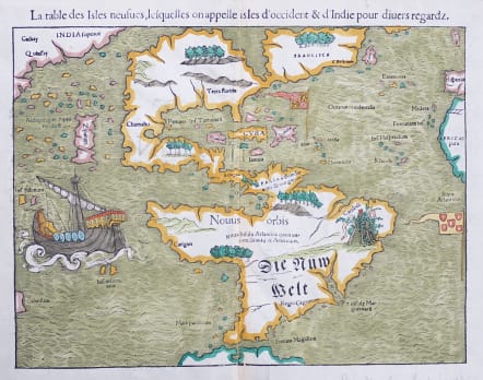
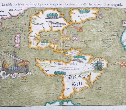
This map of the New World is often credited with popularizing the name America due to the popularity of Munster's Cosmographia and the numerous editions published in the sixteenth century. This map is the 1552 French text edition.
The North American continent is very oddly shaped without a California landmass and the eastern region is nearly bisected by a body of water, known as the Sea of Verrazzano. The Yucatan is still shown as an island, Cozumel is named nearby as Cozumela, and the lake at Temistitan (not named in this state) is connected to the Gulf of Mexico. South America has a large bulge on the western coast, the Amazon River is very short, and cannibals inhabit the continent shown with the name Canibali next to a gruesome vignette with human limbs. The map is very decorative with Magellan's surviving ship Victoria appearing in the Pacific. The flags of Spain and Portugal depict their respective spheres of influence in the New World.
Very good later hand colour.
Excellent condition ..No repairs ..excellent margins
Ref: Burden #12, state 5; Kershaw #4d.
more photos at
https://mickjennings.wordpress.com/2018/02/15/munsters-rare-early-map-of-the-americas-1552/
code : M3908
Cartographer : Sebastian Munster
Date : 1552 Basel
Size : 26*34 cms
availability : Sold
Price : Sold
Originally a scholar studying Hebrew, Greek and mathematics, Sebastian Munster (1489-1552) eventually specialised in mathematical geography and cartography. It was this double ability - as a classicist and mathematician - that was to prove invaluable when Munster set himself to preparing new editions of Solinus’ “Memorabilia” and Mela’s “De Situ Orbis”, two classical descriptive geographies containing maps, and his own two greatest works, the “Geographia” and “Cosmographia”. These reflect the widespread interest in classical texts, which were being rediscovered in the fifteenth century, and being disseminated in the later fifteenth and sixteenth century, through the new medium of printing.
The “Geographia” was a translation of Ptolemy’s landmark geographical text, compiled in about 150 AD., illustrated with maps based on Ptolemy’s calculations, but also, in recognition of the increased geographical awareness, contains a section of modern maps. In the first edition of the “Geographia”, Munster included 27 ancient Ptolemaic maps and 21 modern maps, printed from woodblocks. Subsequent editions of the “Cosmographia” were to contain a vast number of maps and plans.
One consequence of Munster’s work was the impetus it gave to regional mapping of Germany, but Munster was also the first cartographer to produce a set of maps of the four continents on separate maps. Most importantly, through his books (the “Geographia” and “Cosmographia” alone ran to over forty editions in six languages), Munster was responsible for diffusing the most up-to-date geographical information throughout Europe.