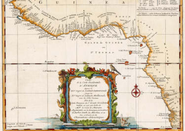
CARTE DE L'ISLE MADAGASCAR
£650
Attractive and scarce, large-scale chart of Madagascar has super topographical detail, soundings, anchorages and place names. An inset "Carte de l'Isle de Madagascar et du Canal de Mozambique" is at top right. This is a Depot de la Marine issue with Prix. Cinquante Sols at bottom right.
Second fold
Very good hand colour
Overall very good condition
code : M4082
Cartographer : Jacques-Nicolas BELLIN
Date : 1765 Paris
Size : 55*90 cms
availability : Available
Price : £650
Jacques-Nicolas Bellin (1703-1772) was one of the most important and prolific French cartographers of the mid-eighteenth century, in the service of the French Hydrographical Office. He was appointed the first Ingenieur Hydrographe de la Marine, and also Official Hydrographer to the French King.
Bellin was responsible for an enormous output of charts and maps. In a large folio format, he issued a volume of sea-charts of France, the Neptune Francois, and several sea-atlases of the World, including the Atlas Maritime and the Hydrographie Francaise. These large charts were amongst the best of the period and continued being reissued throughout the second half of the eighteenth century.
In smaller format, he issued the Petit Atlas Maritime (1764),which contained 580 detailed charts, as well as maps to illustrate l'Abbe Prevost's Histoire Generale des Voyages (1746-1757). Bellin also produced a substantial number of important separately issued maps, particularly reflecting continuing discoveries and political events in the Americas.