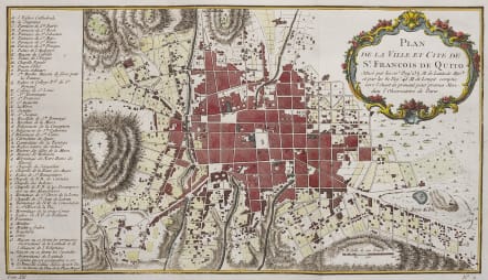
PLAN DE LA VILLE ET CITE DE ST FRANCOIS DE QUITO
£170
Scarce attractive early map of the city of Quito which was previously known as San Francisco de Quito Ecuador. There has been little change in the city since this time.
The map includes an extensive key at left identifying numerous prominent buildings and landmarks. At top right is a superb decorative title.
Excelmlent hand colour
Mint condition
code : M4594
Cartographer : Jacques-Nicolas BELLIN
Date : 1748 Paris
Size : 19*33 cms
availability : Available
Price : £170
Jacques-Nicolas Bellin (1703-1772) was one of the most important and prolific French cartographers of the mid-eighteenth century, in the service of the French Hydrographical Office. He was appointed the first Ingenieur Hydrographe de la Marine, and also Official Hydrographer to the French King.
Bellin was responsible for an enormous output of charts and maps. In a large folio format, he issued a volume of sea-charts of France, the Neptune Francois, and several sea-atlases of the World, including the Atlas Maritime and the Hydrographie Francaise. These large charts were amongst the best of the period and continued being reissued throughout the second half of the eighteenth century.
In smaller format, he issued the Petit Atlas Maritime (1764),which contained 580 detailed charts, as well as maps to illustrate l'Abbe Prevost's Histoire Generale des Voyages (1746-1757). Bellin also produced a substantial number of important separately issued maps, particularly reflecting continuing discoveries and political events in the Americas.