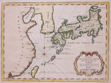
CARTE DES ISLES DU JAPON ET LA PRESQU'ISLE DE COREE ..
£175
Full title Carte Des Isles Du Japon Et la Presqu' Isle De Coree Avec les Costes De La Chine Depuis Pekin Jusqua Canton . . .
Attractive map of Japan & region inc Taiwan.
Decorative cartouche
Excellent hand colour
Very good condition
Included in Antoine-François Prévost d'Exiles' Histoire Générale des voyages, ou nouvelle collection de toutes les relations de voyages par Mer et par Terre ...Published by Didot.
REF: Campbell #60, Walter OAG 93.
code : M4274
Cartographer : Jacques-Nicolas BELLIN
Date : 1754 Paris
Size : 21*28.5 cms
availability : Available
Price : £175
Jacques-Nicolas Bellin (1703-1772) was one of the most important and prolific French cartographers of the mid-eighteenth century, in the service of the French Hydrographical Office. He was appointed the first Ingenieur Hydrographe de la Marine, and also Official Hydrographer to the French King.
Bellin was responsible for an enormous output of charts and maps. In a large folio format, he issued a volume of sea-charts of France, the Neptune Francois, and several sea-atlases of the World, including the Atlas Maritime and the Hydrographie Francaise. These large charts were amongst the best of the period and continued being reissued throughout the second half of the eighteenth century.
In smaller format, he issued the Petit Atlas Maritime (1764),which contained 580 detailed charts, as well as maps to illustrate l'Abbe Prevost's Histoire Generale des Voyages (1746-1757). Bellin also produced a substantial number of important separately issued maps, particularly reflecting continuing discoveries and political events in the Americas.