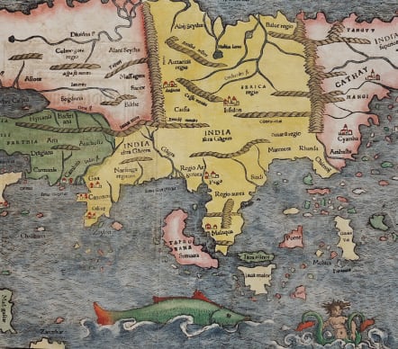
ASIA NEW INDIA MIT VILEN ANSTOSSENDEN LANDERN
£1350
The earliest printed map of the Asian Continent. This map is based on the reports of the Portuguese, Arabs, and Marco Polo. The coast of China begins to emerge in recognizable form, although Japan is not shown yet. The outlines of the Indian subcontinent, between the Indus and the Ganges rivers begins to take a recognizable form, with Zaylon (Sri Lanka) correctly appearing as its own island. The Portuguese outpost of Goa and Calicut, the first place where Vasco da Gama landed in 1497, are depicted. Further to the east Taprobana" (the name Ptolemy gave to Sri Lanka) is also designated as Sumatra.. On the adjacent Malay Peninsula is the important trading port of Malaqua(Malacca). Java is also portrayed, but is depicted as two separate islands. Moloca (The Moluccas), the Spice Islands that were a major point of contention between Spain and Portugal are shown. The resolution of the dispute was the official purpose of Magellan's epic circumnavigation. The depiction of Cathay (China) is shown to be largely predicated on Venetian lore.
Very good hand colour. Good wide margins. Good strong impression;
Very good condition
References: Karrow 59/119c; Clancy, p.64 Map.5.4; Yeo, #2/3
Publication: German edition of Sebastian Münster's Cosmography, titled Cosmographey oder beschreibung aller Länder, Herrschafften, fürnemmsten Stetten, geschichten, gebreüchen, handtierungen &c., published in 1569 by Heinrich Petri in Basel.
code : M4942
Cartographer : Sebastian Munster
Date : 1550 / 1569 Basel
Size : 28.5*35.5 cms
availability : Available
Price : £1350
Originally a scholar studying Hebrew, Greek and mathematics, Sebastian Munster (1489-1552) eventually specialised in mathematical geography and cartography. It was this double ability - as a classicist and mathematician - that was to prove invaluable when Munster set himself to preparing new editions of Solinus’ “Memorabilia” and Mela’s “De Situ Orbis”, two classical descriptive geographies containing maps, and his own two greatest works, the “Geographia” and “Cosmographia”. These reflect the widespread interest in classical texts, which were being rediscovered in the fifteenth century, and being disseminated in the later fifteenth and sixteenth century, through the new medium of printing.
The “Geographia” was a translation of Ptolemy’s landmark geographical text, compiled in about 150 AD., illustrated with maps based on Ptolemy’s calculations, but also, in recognition of the increased geographical awareness, contains a section of modern maps. In the first edition of the “Geographia”, Munster included 27 ancient Ptolemaic maps and 21 modern maps, printed from woodblocks. Subsequent editions of the “Cosmographia” were to contain a vast number of maps and plans.
One consequence of Munster’s work was the impetus it gave to regional mapping of Germany, but Munster was also the first cartographer to produce a set of maps of the four continents on separate maps. Most importantly, through his books (the “Geographia” and “Cosmographia” alone ran to over forty editions in six languages), Munster was responsible for diffusing the most up-to-date geographical information throughout Europe.