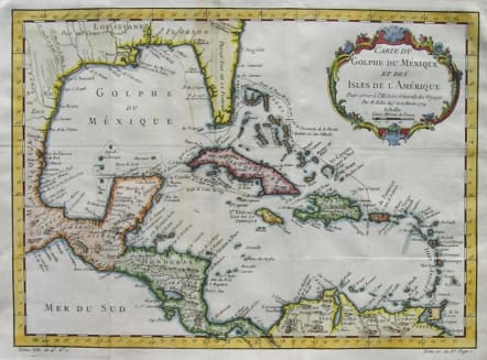
WEST INDIES CARTE DU GOLPHE DU MEXIQUE ET DES ISLES DE L'AMERIQUE
£245
A strong, dark impression of Bellin's beautifully engraved map of the West Indies and Gulf Coast from the atlas of Prevost d'Exiles' influential Histoire Generale des Voyages. The highly detailed map includes the routes of the conquistadors Ponce de Leon, Hernandez de Cordoba, and Cortez, as well as a delightful scrollwork and floral cartouche. Excellent hand colour.Printed on heavy paper.A superb map in very good condition.
code : M2463
Cartographer : Jacques-Nicolas BELLIN
Date : 1754 Paris
Size : 28.5*39cms
availability : Available
Price : £245
Jacques-Nicolas Bellin (1703-1772) was one of the most important and prolific French cartographers of the mid-eighteenth century, in the service of the French Hydrographical Office. He was appointed the first Ingenieur Hydrographe de la Marine, and also Official Hydrographer to the French King.
Bellin was responsible for an enormous output of charts and maps. In a large folio format, he issued a volume of sea-charts of France, the Neptune Francois, and several sea-atlases of the World, including the Atlas Maritime and the Hydrographie Francaise. These large charts were amongst the best of the period and continued being reissued throughout the second half of the eighteenth century.
In smaller format, he issued the Petit Atlas Maritime (1764),which contained 580 detailed charts, as well as maps to illustrate l'Abbe Prevost's Histoire Generale des Voyages (1746-1757). Bellin also produced a substantial number of important separately issued maps, particularly reflecting continuing discoveries and political events in the Americas.


