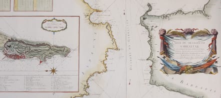


CARTE DE DETROIT DE GIBRALTER
£485
Full Tityle: Carte du Detroit de Gibraltar Dressée au Depost des Cartes et Plans de la Marine pour le service des Vaisseaux du Roy par Ordre de M. le Duc de Choiseul Ministre de la Guerre et de la Marine.
Attractive and detailed chart prepared by J.N. Bellin of the Straits of Gibraltar locating harbors and bays and coastal soundings. Decorative title cartouche. Depicts Cape Trafalgar, Cape Marinal, the Bay of Gibraltar and Cape Spartel and Cape Malabare on the Moroccan coast. Upper left is a tide Chart and center left an inset plan of Gibraltar with a key from A-Z and a-k of the important sites and fortifications.
Attractive inset viea of Giibralter
Superb large cartouche.
Stunning map in near mint condition
code : M4396
Cartographer : Jacques-Nicolas BELLIN
Date : 1761 Paris
Size : 57*88 cms
availability : Available
Price : £485
Jacques-Nicolas Bellin (1703-1772) was one of the most important and prolific French cartographers of the mid-eighteenth century, in the service of the French Hydrographical Office. He was appointed the first Ingenieur Hydrographe de la Marine, and also Official Hydrographer to the French King.
Bellin was responsible for an enormous output of charts and maps. In a large folio format, he issued a volume of sea-charts of France, the Neptune Francois, and several sea-atlases of the World, including the Atlas Maritime and the Hydrographie Francaise. These large charts were amongst the best of the period and continued being reissued throughout the second half of the eighteenth century.
In smaller format, he issued the Petit Atlas Maritime (1764),which contained 580 detailed charts, as well as maps to illustrate l'Abbe Prevost's Histoire Generale des Voyages (1746-1757). Bellin also produced a substantial number of important separately issued maps, particularly reflecting continuing discoveries and political events in the Americas.