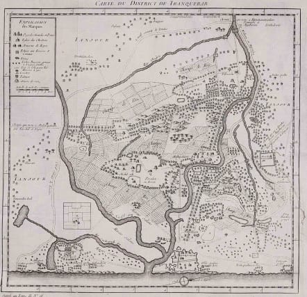
CARTE DU DISTRICT DE TRANQUEBAR
Sold
Detailed map of the area around Tranquebar (now Tharangambadi), an early Danish Trading Colony in modern Indian state of Tamil Nadu.
Shows the detailed area around the fortified trading post, including rivers, roads and other details.
Small invisible repair where map was attached.
Good condition.
code : M2973
Cartographer : Jacques-Nicolas BELLIN
Date : 1760c Paris
Size : 31*31.5 cms
availability : Sold
Price : Sold
Jacques-Nicolas Bellin (1703-1772) was one of the most important and prolific French cartographers of the mid-eighteenth century, in the service of the French Hydrographical Office. He was appointed the first Ingenieur Hydrographe de la Marine, and also Official Hydrographer to the French King.
Bellin was responsible for an enormous output of charts and maps. In a large folio format, he issued a volume of sea-charts of France, the Neptune Francois, and several sea-atlases of the World, including the Atlas Maritime and the Hydrographie Francaise. These large charts were amongst the best of the period and continued being reissued throughout the second half of the eighteenth century.
In smaller format, he issued the Petit Atlas Maritime (1764),which contained 580 detailed charts, as well as maps to illustrate l'Abbe Prevost's Histoire Generale des Voyages (1746-1757). Bellin also produced a substantial number of important separately issued maps, particularly reflecting continuing discoveries and political events in the Americas.


