CARTE DU LAC DE MEXICO ET DE SES ENVIRONS
£80
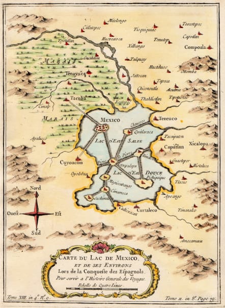
Detailed and attractive map of the lake and Mexico city during the Sixteenth century.
the Aztec capital of Tenochtitlan was one of the largest urban centers in the western hemisphere. It can been seen here, built on a group of islands in the middle of a large lake linked by elevated dirt causeways.
The size and population of the city and in the surrounding region awed the invading conquistadors. After the natives were devastated by infighting and disease, the area was quickly re-settled as Mexico City and quickly rose again to prominence as one of the largest urban areas in the hemisphere.
Good hand colour
Very good condition
code : M4623
Cartographer : Jacques-Nicolas BELLIN
Date : 1757 Paris
Size : 22*16 cms
availability : Available
Price : £80
Jacques-Nicolas Bellin (1703-1772) was one of the most important and prolific French cartographers of the mid-eighteenth century, in the service of the French Hydrographical Office. He was appointed the first Ingenieur Hydrographe de la Marine, and also Official Hydrographer to the French King.
Bellin was responsible for an enormous output of charts and maps. In a large folio format, he issued a volume of sea-charts of France, the Neptune Francois, and several sea-atlases of the World, including the Atlas Maritime and the Hydrographie Francaise. These large charts were amongst the best of the period and continued being reissued throughout the second half of the eighteenth century.
In smaller format, he issued the Petit Atlas Maritime (1764),which contained 580 detailed charts, as well as maps to illustrate l'Abbe Prevost's Histoire Generale des Voyages (1746-1757). Bellin also produced a substantial number of important separately issued maps, particularly reflecting continuing discoveries and political events in the Americas.


