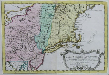
NEW ENGLAND NEW YORK CARTE DE LA NOUVELLE ANGLETERRE NOUVELLE YORK ET PENSILVANIE
Sold
Superb map exceptionally in full original colour. RARE
Map of New England, New York and Pennsylvania at the time of the French and Indian War. Many familiar cities and towns appear along the coasts and rivers, but the interior remains largely unsettled. The area just east of the Appalachians is labeled “Parts Unknown”, with a scattering of Indian settlements. A number of forts are shown, mostly in the vicinity of the Great Lakes and Lake Champlain. Bellin was Hydrographer in the French Dépôt de la Marine and produced a great many maps and charts of high quality.
The map was issued in Bellin's Histoire Generale des Voyages.
Very good condition.
code : M2469
Cartographer : Jacques-Nicolas BELLIN
Date : 1750c Paris
Size : 20.5*30cms
availability : Sold
Price : Sold
Jacques-Nicolas Bellin (1703-1772) was one of the most important and prolific French cartographers of the mid-eighteenth century, in the service of the French Hydrographical Office. He was appointed the first Ingenieur Hydrographe de la Marine, and also Official Hydrographer to the French King.
Bellin was responsible for an enormous output of charts and maps. In a large folio format, he issued a volume of sea-charts of France, the Neptune Francois, and several sea-atlases of the World, including the Atlas Maritime and the Hydrographie Francaise. These large charts were amongst the best of the period and continued being reissued throughout the second half of the eighteenth century.
In smaller format, he issued the Petit Atlas Maritime (1764),which contained 580 detailed charts, as well as maps to illustrate l'Abbe Prevost's Histoire Generale des Voyages (1746-1757). Bellin also produced a substantial number of important separately issued maps, particularly reflecting continuing discoveries and political events in the Americas.


