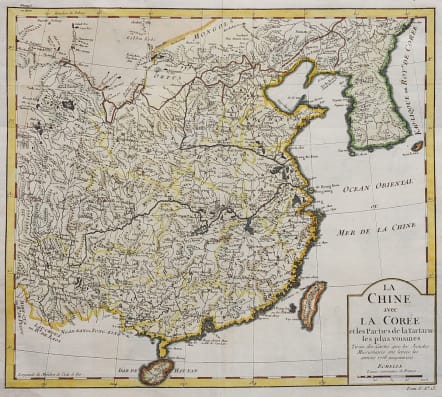
LA CHINE AVEC LA COREE
Sold
Full Title: La Chine avec La Coree et les Parties de la Tartarie les plus voisines Tirees des Cartes que les Jesuites Missionaires ont levees les annees 1708 jusquen 1717.
Attractive and detailed map of China, Korea and Taiwan (named as Tayouan ou Formose I.). Prepared after Jesuit sources from 1708-1717.
The map is of interest for the use of "Kao-Liqoue ou Roy.e de Corée". This well-known map of mainland China, Taiwan and Korea is prepared by Jacques Nicolas Bellin.
The map was published in 1748 in Prévost d´Exiles ´Histoire General des Voyages…´
Good hand colouring
Very good condition
code : M4575
Cartographer : Jacques-Nicolas BELLIN
Date : 1748 Paris
Size : 28*32 cms
availability : Sold
Price : Sold
Jacques-Nicolas Bellin (1703-1772) was one of the most important and prolific French cartographers of the mid-eighteenth century, in the service of the French Hydrographical Office. He was appointed the first Ingenieur Hydrographe de la Marine, and also Official Hydrographer to the French King.
Bellin was responsible for an enormous output of charts and maps. In a large folio format, he issued a volume of sea-charts of France, the Neptune Francois, and several sea-atlases of the World, including the Atlas Maritime and the Hydrographie Francaise. These large charts were amongst the best of the period and continued being reissued throughout the second half of the eighteenth century.
In smaller format, he issued the Petit Atlas Maritime (1764),which contained 580 detailed charts, as well as maps to illustrate l'Abbe Prevost's Histoire Generale des Voyages (1746-1757). Bellin also produced a substantial number of important separately issued maps, particularly reflecting continuing discoveries and political events in the Americas.


