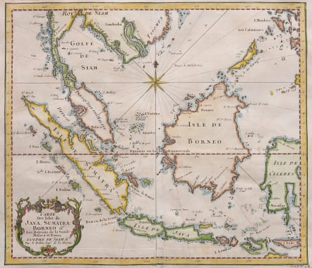
CARTE DES ISLES DE JAVA SUMATRA BORNEO
Sold
Detailed regional map, extending from the Gulf of Siam and Mindoro to Timo, Java and Sumatra, centered on Borneo and the Malay Peninsula.
Large decorative compass rose and cartouche.
Excellent hand colour
Small repair at rear of map at bottom of centre fold otherwise
Very good condition.
code : M4673
Cartographer : Jacques-Nicolas BELLIN
Date : 1750 Paris
Size : 25.5*29.5 cms
availability : Sold
Price : Sold
Jacques-Nicolas Bellin (1703-1772) was one of the most important and prolific French cartographers of the mid-eighteenth century, in the service of the French Hydrographical Office. He was appointed the first Ingenieur Hydrographe de la Marine, and also Official Hydrographer to the French King.
Bellin was responsible for an enormous output of charts and maps. In a large folio format, he issued a volume of sea-charts of France, the Neptune Francois, and several sea-atlases of the World, including the Atlas Maritime and the Hydrographie Francaise. These large charts were amongst the best of the period and continued being reissued throughout the second half of the eighteenth century.
In smaller format, he issued the Petit Atlas Maritime (1764),which contained 580 detailed charts, as well as maps to illustrate l'Abbe Prevost's Histoire Generale des Voyages (1746-1757). Bellin also produced a substantial number of important separately issued maps, particularly reflecting continuing discoveries and political events in the Americas.


