LONDON MAP A PLAN OF THE CITY AND SUBURBS OF LONDON
Sold
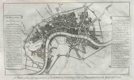
Title: 'A plan of the City and suburbs of London as fortified by order of Parliament in the years 1642 & 1643'. Publication: Maitland's History of London A fascinating and important map of London as it was at the time of the Civil War and before the Great Fire. The engraving was originally prepared by G. Vertue in 1738 and later published with Maitland's History of London in 1756. This map shows the City of London and the various defences erected by Parliament during the Civil War against King Charles I during the 1640's. Two panels give an explanation of the 23 forts on the lines of defence. Mint condition.
REF:
code : M2235
Cartographer : ANON
Date : 1738 London
Size : 22*36cms
availability : Sold
Price : Sold


