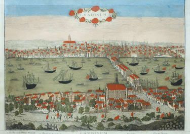
A NEW AND ACCURATE PLAN OF THE CITIES OF LONDON AND WESTMINSTER AND BOROUGH OF SOUTHWARK WITH THE NEW ROADS & NEW BUILDINGS &c TO THE YEAR 1765
£550
Rare map London dated 1765.
Covers the area from Hyde Park, Sadlers Wells ( the Well) to White Chapel. Looks like Old Colour.
Detailed and very finely engraved.
The nearest example in the British Library (see ref below) although that copy is different in 3 ways ..
1. The date 1765 is wriiten by hand on BL map
2. There is a distance bar on BL map
3. This example was from 2 seperate sheets joined later. Under the description of the BL example a Mr Hancks found the left hand portion of the map and presumes it came from the Gentleman's Magazine and prinbted in 2 parts in 1763 & 1764 according to UCL library .However the right hand version in this example has 1765 printed whereas Gents Mag. Does not.
And the example here the 2 sheets do not join exactly ..(the left slightly larger).
Interesing and rare map of London in V Good condition with old colour.
Very Similar map from the Crace Collection in British Library
http://www.bl.uk/onlinegallery/onlineex/crace/a/007zzz000000004u00127000.html
code : M3728
Cartographer : ANON
Date : 1765 London
Size : 40*66 cms
availability : Available
Price : £550