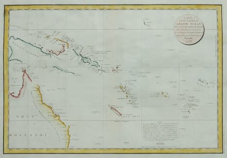


CARTE D'UNE PARTIE DE GRAND OCEAN AUSTRALIA NEW GUINEA ..
£300
Attractive and important map covering the discoveries of this Australia, New Guinea, Soloman Isles, Fiji, Isles des Amis.
Shows the routes taken by the Spanish explorer Don Francisco Antonio Maurelle in 1781 along the northern coast of New Guinea and across the Pacific to Fiji and Tonga. Maurelle was credited with the discovery of the Hermit Islands on this voyage. The map includes the north-eastern coast of Australia, and parts of the coast of New Guinea. The map shows the 1781 route of his ship "The Princesa" through the Bismarck Archipelago north of New Guinea, through the Archipel de Salomos i.e. Solomon Islands and then east across the Pacific to the Iles de Amis i.e. the Friendly Islands, now Tonga where he discovered I. Vavao i.e. Vava'u with one of the best anchorages in the South Pacific. The map includes the Iles de Navigateurs i.e. Samoa, I. Fidji i.e. Fiji, Iles de Esprit i.e. Vanuatu or the New Hebrides Isles, and Nouvelle Caledonie i.e. New Caledonia. Many small islands are depicted with notes regarding their sightings by Abel Tasman, William Bligh and Maurelle.
Good hand colour
Excellent condition for this important map.
code : M4834
Cartographer : ANON
Date : 1797 Paris
Size : 34*49 cms
availability : Available
Price : £300