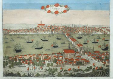
PLAN VAN LONDON WESTMUNSTER EN SOUTHWARK PLAN DE LONDRES WESTMUNSTER & SOUTHWARK
£650
An original antique copper engraving in excellent hand colour.
A rare map of London engraved by Cornelius van Baarsel and published by François Bohn in Harlem circa 1765. The title is in German and French.
Shows London's limits in the mid Eighteenth century with Blackfriars Bridge shown before its opening in 1769, with no link road to the south; Arlington House is marked despite being replaced by Buckingham House in 1703; and St James' Park has 'The Decoy', a system of channels surrounded by shubbery where ducks could be caught for the king's table, now 'Duck Island'
A good size map in very good condition
Published by Francois Bohn, Haarlem, 1788.
Made by ‘Cornelis van Baarsel’ after an anonymous artist. Cornelis van Baarsel (1761 – 1826), Dutch engraver / cartographer.
HOWGEGO: 136
code : M4750
Cartographer : ANON
Date : 1765c Harlem
Size : 36*65 cms
availability : Available
Price : £650