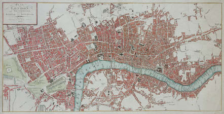
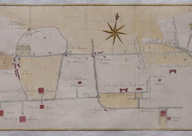
PLAN VON LONDON UND WESTMINSTER UND BOROUGH VON SOUTHWICK
Sold
Uncommon and very attractive copper engraved map of London at the beginning of the nineteenth century, published by the Weimar Institute.
Covers the area from Sloane Street to the Mile End Road, Borough to Islington.
Box title.
Excellent and colour.
Very good condition.
code : M4228
Cartographer : ANON
Date : 1809
Size : 26*50 cms
availability : Sold
Price : Sold

Pacific & Australasia

Greece

£35
France

British Isles

Pacific & Australasia


Scandinavia


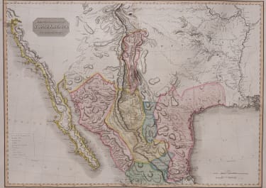
North America

Europe Continent

Italy

North America

France

Pacific & Australasia

France


British Isles

France

France

Africa

South America

Middle East

Asia

North America

South America

Spain & Portugal

France

Pacific & Australasia

Scandinavia
North America

Italy


World

Pacific & Australasia

South America

France

France


South America

North America

South America


World

North America

North America

Russia

North America

British Isles


North America

France

France

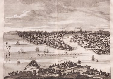
Middle East


North America

Greece

British Isles


France

North America

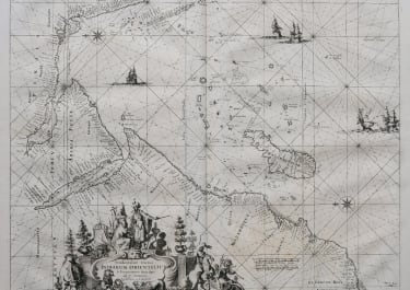
West Indies


Pacific & Australasia

Africa

British Isles


Switzerland

North America


West Indies

France

France

Central America

Low Countries

North America

Africa

Africa


France

France

France

France

France

British Isles
British Isles

Middle East

Italy
France

South America


The Americas

British Isles


Middle East

Asia

Asia


Pacific & Australasia


France


Mediterranean & Islands

£175
Italy


World

France


£45
British Isles

Low Countries

£55
Pacific & Australasia

£135
British Isles

£125
France

£45
Italy

£50
France

£75
Scandinavia

£245
British Isles

£395
France

£195
North America

£85
World

£75
Italy

Middle East

Middle East

Middle East

Middle East

British Isles


British Isles

£225
Middle East

£120
British Isles


£85
West Indies

France

£95
West Indies

Asia

£165
France


France

£185
North America

North America

British Isles


Middle East

British Isles

Pacific & Australasia

North America

£125
North America

British Isles

Asia

Europe Continent

South America

Spain & Portugal

World

Italy
Middle East

France


France

British Isles

North America

Asia


North America


France

British Isles


£100
Italy


Africa
Pacific & Australasia
Greece
£35
France
British Isles
Pacific & Australasia
Scandinavia
North America
Europe Continent
Italy
North America
France
Pacific & Australasia
France
British Isles
France
France
Africa
South America
Middle East
Asia
North America
South America
Spain & Portugal
France
Pacific & Australasia
Scandinavia
North America
Italy
World
Pacific & Australasia
South America
France
France
South America
North America
South America
World
North America
North America
Russia
North America
British Isles
North America
France
France
Middle East
North America
Greece
British Isles
France
North America
West Indies
Pacific & Australasia
Africa
British Isles
Switzerland
North America
West Indies
France
France
Central America
Low Countries
North America
Africa
Africa
France
France
France
France
France
British Isles
British Isles
Middle East
Italy
France
South America
The Americas
British Isles
Middle East
Asia
Asia
Pacific & Australasia
France
Mediterranean & Islands
£175
Italy
World
France
£45
British Isles
Low Countries
£55
Pacific & Australasia
£135
British Isles
£125
France
£45
Italy
£50
France
£75
Scandinavia
£245
British Isles
£395
France
£195
North America
£85
World
£75
Italy
Middle East
Middle East
Middle East
Middle East
British Isles
British Isles
£225
Middle East
£120
British Isles
£85
West Indies
France
£95
West Indies
Asia
£165
France
France
£185
North America
North America
British Isles
Middle East
British Isles
Pacific & Australasia
North America
£125
North America
British Isles
Asia
Europe Continent
South America
Spain & Portugal
World
Italy
Middle East
France
France
British Isles
North America
Asia
North America
France
British Isles
£100
Italy
Africa
Pacific & Australasia