CARTE DE LA MERIDIENE MESUREE ROYAUME DE QUITO
Sold
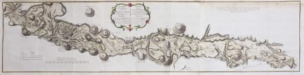
Full French Title : Carte de la Meridiene mesurée au Royaume de Quito; Par ordre du Roy notre Souverain pour parvenir à la Connoissance du Dégré Teirestre et de la figure de la teire par D. Jorge Juan et D. Ant. de Ulloa en 1744. Cartographer :De la Condamine / Juan & Ulloa
The scarce monumental chart carried out by the Geodesic Mission shows the length of a one degree of meridian at the equator near and centered on Quito, The High Andes encompassing the Volcanos and in fact the highest point on earth to the stars ( due to the equatorial bulge).
Covers the area from the Carchi Province in the north to Cañar Province in the south.
Superb detail the map gives great topographical detail of the area to the east and west of Quito, Ecuador. A series of triangulation lines are depicted based on the measurements by Ulloa and Juan. Numerous small towns, villages, rudimentary roads, and even volcanoes are identified.
Three sheets joined , manuscript tramline at top right corner
Excellent hand colour
Very good condition.
.
The French Geodesic Mission
In August 1737, French scientists, having traveled across the Atlantic to Ecuador, split into two groups and departed Quito for separate peaks. They would battle altitude sickness a condition Europeans were oblivious to and freezing cold to reach their respective summits and begin their work of triangulation.
At their destinations, the teams each erected a huge pyramid of wood and cotton that could be seen from 30 miles away. For 23 days straight, cloud, fog and mist prevented them from measuring a single angle, and they were forced to return to Quito no closer to their goal. The French Geodesic Mission to the Equator left France in 1735 to determine whether the Earth was squeezed at the Equator, as followers of René Descartes believed, or flattened at the poles, as English upstart Isaac Newton maintained.
References: cf. Shirley (BL Atlases) G.ULL-1a #5.
Publication : de la Condamine's landmark Journal du Voyage Fait par Ordre du roi a l'Equateur, which contains the first scientific account of the Amazon.
code : M4556
Cartographer : ANON
Date : 1751 Leipzig
Size : 24*100.5 cms
availability : Sold
Price : Sold


